The
Awesome Mt. Rainier Wave
 "All evidence available tends to show
that Rainier is an extinct volcano. It belongs, however, to the
explosive type of volcanoes, of which Vesuvius is the best-known
example, and there is no assurance that its energies may not be
reawakened." Israel C. Russell, 1898
"All evidence available tends to show
that Rainier is an extinct volcano. It belongs, however, to the
explosive type of volcanoes, of which Vesuvius is the best-known
example, and there is no assurance that its energies may not be
reawakened." Israel C. Russell, 1898
On September 28, 1997, the Mountain showed its awesome
power through not a volcanic but an atmospheric eruption. This is
one glider pilot's account. By Vitek Siroky,
"CD"
This story would not be possible if it were not for the
unceasing efforts of many gliding enthusiasts, most notably of
Norman Ellison ("BH") who for the past seven years has
been fighting for the preservation of Ranger Creek airstrip 15
miles NW of Mt. Rainier summit as a protected and active airport.
The Washington Department of Aeronautics let its lease with the
US Forest Service (FS) lapse some time ago much to the delight of
the FS who had enough trouble tending to the encroachment of ORV
(off-the-road-vehicles) people, motor homes, dirtbikers,
horseback riders, etc. on the airstrip. Norman went to countless
meetings, kept on convincing and eventually succeeded in getting
the State to renew its lease with the FS, get it reopened to
aviation use, and even get the airstrip repaved. Thank you very
much, Norm.
Also thanks go to this year's Mt. Rainier Wave Camp organizer
John Gilbert who got on the Internet and roused interest in our
glider community. And for this particular weekend thanks go to my
supporting wife Emily who got me out-the-door, also to Pierre
Parent, the towpilot, the hapless glider pilots who came on
Saturday, assembled but didn't get to fly - Steve Northcraft and
Mike Newgard, to Bob and Lisa Hills who came scouting the field
Saturday evening and promised to come the next day with their
glider, then on Sunday thanks to the cooperative air traffic
controllers at the Seattle Center, and finally thanks to The
Mountain and its "Weather Gods".
About ten years ago I did get to fly once from Ranger Creek. A
vague memory of a stable day with polishing the Sunrise Lodge
parking lot for two hours comes to mind; and of the eventual
descent and search for the airstrip hidden in the narrow White
River valley, landing to the south. When I read of this years
Camp I got charged up, but a lot was needed to overcome the
prospect of non-flying or "just" stable days. On
Saturday at eleven in the morning of the first day of the Camp I
was still helping my family with the garage sale at our home in
Wenatchee, 190 road miles distant from Ranger Creek. There were
lennies all over the eastern Cascades but rain and overcast was
in forecast for western Washington, with possibly an improvement
on Sunday. Why not stay here and enjoy flying locally? It must be
the mystical lore and powerful magnetism of Mt. Rainier and its
fabulous wave potential that would make one pack up and go. I
called Pierre Parent on his cell phone, he confirmed he was
planning to tow, so I said - "see you in about four
hours". Parting with my family and hooking up "CD"
stowed in its trailer took just minutes.
Taking the southern route via Yakima and watching the sky
dotted with lenticulars, the prospect of soaring at Ranger Creek
appeared more and more appetizing. However, driving into the
clouds at the summit of Chinook Pass I might have to console
myself with a thought of bragging to those at Ranger Creek that
"my glider got to 5,500' today" . However, to my
surprise, as I emerged on the west side just north of Cayuse Pass
along Highway 410, the clouds parted and there was a nice wide
opening above the valley. Arriving at Ranger Creek at half past
three I expected glider activity there but to my surprise there
were only just the usual ORV crowds. In the meantime two great
looking lenticulars were visible to the south and one to the
west. I overheard myself pondering - how come no one's flying?!
Talking to a park ranger and several people I gathered the story
that a couple of gliders were there but they packed up and left
just before I arrived; and that no power plane came. For one hour
I kept cursing, but then low clouds came in, totally closing and
sealing off any chance for pilots who might have been above to
come safely down. Sobered up, I wandered about when I spotted an
SSA sticker on a van in which Bob and Lisa Hills had come to
scout the field. They ran into Steve, Mike and Pierre at the
Naches Tavern in Greenwater and heard their story, and filled me
in. Pierre had driven over from Bergseth to tell he couldn't get
in because of low ceilings. I was pleased to hear that Bob had
decided to come the next day and bring his SZD-55 "7V"
(soon to be "7U"). After they left I phoned the wave
camp coordinator, briefed his wife in, and parked in the
beautiful lush forest setting with a good book. Turning in early
and with sky still totally obscured, I didn't carry much hope for
the next day. Much to my surprise when I woke up in the middle of
the night the sky was covered with the most brilliant stars I've
seen in a long time. Maybe a hope?
 But the morning again delivered thick clouds rolling
overhead, so I resigned myself to taking a very enjoyable walk
through the surrounding woods expecting it to be the highlight of
the weekend. Then - suddenly - there was sunlight! I moved to the
north end of the field in eager expectancy of someone else
showing up - the first one was Pierre shortly after 10am making a
low pass in the SGC Pawnee to chase out the ORV crowd from the
runway. I got really excited: the signs of a possible wave,
towpilot arriving, the access path open! Somehow I didn't want to
be up there alone, however. Slowly I started rigging. Eventually
Bob & Lisa showed up - company! Also from onlookers - a lady
on horseback, state patrol, ORV people, motor homers.
But the morning again delivered thick clouds rolling
overhead, so I resigned myself to taking a very enjoyable walk
through the surrounding woods expecting it to be the highlight of
the weekend. Then - suddenly - there was sunlight! I moved to the
north end of the field in eager expectancy of someone else
showing up - the first one was Pierre shortly after 10am making a
low pass in the SGC Pawnee to chase out the ORV crowd from the
runway. I got really excited: the signs of a possible wave,
towpilot arriving, the access path open! Somehow I didn't want to
be up there alone, however. Slowly I started rigging. Eventually
Bob & Lisa showed up - company! Also from onlookers - a lady
on horseback, state patrol, ORV people, motor homers.
By now most of the sky above the valley was free of clouds,
and to the south there were again the wispy lennies. But how to
get to them - they appeared so far and so high. Would there be a
way to climb from the usual release spot over the Sunrise Lodge
parking lot, the only one I was familiar with? And then how to
get back, would the breaks in the low cloud cover hold up?
Eventually, at about 12:30 pm I towed up to the north. On
take-off I yelled to myself the emergency chants, "straight
ahead-straight ahead-one eighty - one eighty" - then a
realization came that after the flight I'd have to come land here
again (there was nowhere else to land). We made a 180 turn to the
south along the hills on the west side of the White River valley
(with water brown chalky white from grinding glaciers) - quickly
rising to cloud base at about 6,000'. Pierre called - "what
do you want to do now?" The whole sky appeared just blocked
by the grayness of cloudbases. Just across the valley, the upper
stations of the Crystal Mountain ski lifts were cut off by
clouds. However, above the valley there was a mile-wide gap
between clouds extending to the south for about two miles, and
around the corner to the west for about another mile - in the
direction of Sunrise Lodge. So I told Pierre to tow up into it.
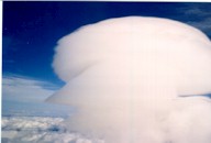
 As we emerged from the valley gap and could see over
the tops of the surrounding lower clouds then we spotted it: the
enormous awesome stack of lenticulars about another five miles
upwind from us - sitting right over Little Tahoma Peak, 11,100'.
Judging by the shape of the lennies and the shape of the cap
cloud veiling the entire top of Mt. Rainier, the wind must have
been directly from the west. There was no way to get to the area
of lift from the usual release point over the Sunrise Lodge. I
decided to hang on tow even though it meant going a lot higher
than the 7,500' I wrote on the towcard. Pierre turned us around
to the east and we started going through some pretty rough air
getting rope slack a number of times. By the time we were
half-way between Highway 410 and Sunrise Lodge we cleared the
tops of the lower clouds at about 9,000'. We turned west again
and proceeded very slowly upwind straight ahead toward the large
blue hole over Emmons Glacier from which shreds of rotors were
shooting up toward the stacks of lenticular "dishes".
Eventually I convinced myself it was time to cut the umbilical
cord connecting me with Pierre and I released at 11,500'.
As we emerged from the valley gap and could see over
the tops of the surrounding lower clouds then we spotted it: the
enormous awesome stack of lenticulars about another five miles
upwind from us - sitting right over Little Tahoma Peak, 11,100'.
Judging by the shape of the lennies and the shape of the cap
cloud veiling the entire top of Mt. Rainier, the wind must have
been directly from the west. There was no way to get to the area
of lift from the usual release point over the Sunrise Lodge. I
decided to hang on tow even though it meant going a lot higher
than the 7,500' I wrote on the towcard. Pierre turned us around
to the east and we started going through some pretty rough air
getting rope slack a number of times. By the time we were
half-way between Highway 410 and Sunrise Lodge we cleared the
tops of the lower clouds at about 9,000'. We turned west again
and proceeded very slowly upwind straight ahead toward the large
blue hole over Emmons Glacier from which shreds of rotors were
shooting up toward the stacks of lenticular "dishes".
Eventually I convinced myself it was time to cut the umbilical
cord connecting me with Pierre and I released at 11,500'.
I still needed another half a mile to get to the lower shreds
of the rotors. Then the vario started its violent peg-to-peg
dance. Startled, I had to apply my willpower not to turn around.
Drawing on prior experience I convinced myself to keep on
bouncing straight into the face of the jungle of glaciers filling
the entire windshield. In the meantime I started the routine of
donning the oxygen mask, turning on the flow, tightening all
belts, etc. Eventually I reached the most upwind area of the
rotor shreds at 11,000' and hit one that gave lift for more than
three seconds. I circled sharply to the right and by the time the
glider faced west again the altimeter showed we had gained almost
1,000' - in just one turn! This fact gave me the confidence that
I could stay up and not get washed down into the gaping hole
below. I started exploring upwind even closer to the east face of
the Mountain, and soon broke into "the smooth" of the
wave. The vario immediately pegged up, the digital averager
indicated over sixteen knots of climb, and before I knew it we
were at 14,500'.
There was a veil flowing over the top of Mt. Rainier. I moved
towards it to cancel out lift to gain time to hopefully get the
wave window opened. On the ground we couldn't find the phone
number - we could have used Pierre's cell phone. I towed up in
blind faith that Seattle Center air traffic controllers would be
cooperative even if we'd just call them on the radio. At ten
minutes to one, the talk on 126.1 MHz sounded quite intimidating,
to hear all the "heavy" jets being directed to Sea-Tac.
I tried to sound official as I pleaded, "This is glider 62TM
three miles east of Mt. Rainier at 15,000' requesting opening of
Mt. Rainier glider wave window". At first there was silence.
Two minutes later I repeated and a voice came on, "...What
glider is calling Seattle Center?" - so I repeated my
request. Center: "Do you have an operating
transponder?" Me: "Negative". Center "What
glider group do you belong to" - "Seattle Glider
Council" - "Standby, we are researching" - now it
was five to one - and I had to move again upwind to maintain
altitude. To pass the time, I attempted to take a picture of the
cap cloud veiling the summit. At one o'clock the Center came
back, "...We found the procedure and we will accommodate you
62TM, switch to 126.6 for further directions." Well - this
sounded very promising. I gladly obliged and after several more
exchanges taking probably another ten minutes (at the most) we
were cleared until 4 pm to flight level 230 with a prospect of
getting an extension. I radioed Pierre but could not raise him;
decided would try a little later. Without anyone else to talk to,
I started silently talking to myself: Check oxygen bottle
pressure, look at finger nails, how much is 11500 plus 16400? (I
would make these checks every two minutes from that moment on, to
make sure I wasn't becoming hypoxic).
I made a left turn to drift into the lift. While snapping a
picture of the stack of lennies to the east of me with their
lower bases now just about on the horizon I instantly shot up. I
quickly pointed the glider west at 45 knots indicated. The
altimeter started unwinding like a top - 16 - 17 - ... 21,000'.

There I made another circle and took a
"turnpoint-like" picture of the stack of lennies - now
I was almost above them. All along the wave lift continued in
excess of 1,000 fpm. It was time to 'park upwind' again and call
the Center for the altitude extension. While waiting I snapped a
picture of the top of Mt. Rainier, at this time looking down at
it, and through the veil of the cap cloud just barely
distinguishing the Columbia Crest crater on the left.
 The kind controller quite quickly granted an
extension to FL280, so I backed into the lift. I also overheard
someone on 126.6 say, "That's quite impressive." With
further climb, the intensity of lift gradually started to drop -
600 fpm at 25,000' to eventually 200 fpm at 27,200' - the highest
point I decided to go to. In the meantime I talked to glider
pilots from Portland and invited them to Ranger Creek for the
next two weekends, and to Norm Ellison who had just towed up at
Ephrata.
The kind controller quite quickly granted an
extension to FL280, so I backed into the lift. I also overheard
someone on 126.6 say, "That's quite impressive." With
further climb, the intensity of lift gradually started to drop -
600 fpm at 25,000' to eventually 200 fpm at 27,200' - the highest
point I decided to go to. In the meantime I talked to glider
pilots from Portland and invited them to Ranger Creek for the
next two weekends, and to Norm Ellison who had just towed up at
Ephrata.
 I took a few more
pictures to show the panorama to the south with Mt. St. Helens,
Mt. Hood, and Mt. Adams all visible (the latter just below the
wing, with a cap cloud and a lennie downwind).
I took a few more
pictures to show the panorama to the south with Mt. St. Helens,
Mt. Hood, and Mt. Adams all visible (the latter just below the
wing, with a cap cloud and a lennie downwind).
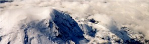
Also I snapped a view of the summit of Mt. Rainier below me,
now the cap cloud almost dissolved - the wind must have started
to abate.
 At that realization, I decided to drift downwind to
the area just east of Chinook Pass from where I had a clear
visual on Ranger Creek airport. With trepidation (would they get
stuck open?) I opened the spoilers and started descending. From
about 18,000' I took my last aerial photo showing Rainier without
its cap, the stack of lennies over Little Tahoma totally gone,
and the blue hole to the south of Sunrise Lodge gradually filling
with low clouds. These clouds apparently must have looked pretty
menacing from the ground. Bob Hills in his 7V delayed takeoff for
almost two hours. Eventually he took off behind Pierre; I could
spot them from that high. Bob told me he had no oxygen on board
and that he would not need the wave window kept open. So at about
three o'clock I closed it. At first I couldn't connect on 126.6
for there I heard a constant broadcast of Vancouver B.C. ATIS but
eventually succeeded at 126.1, and thanked the controllers
profusely for accommodating us on such a short notice.
At that realization, I decided to drift downwind to
the area just east of Chinook Pass from where I had a clear
visual on Ranger Creek airport. With trepidation (would they get
stuck open?) I opened the spoilers and started descending. From
about 18,000' I took my last aerial photo showing Rainier without
its cap, the stack of lennies over Little Tahoma totally gone,
and the blue hole to the south of Sunrise Lodge gradually filling
with low clouds. These clouds apparently must have looked pretty
menacing from the ground. Bob Hills in his 7V delayed takeoff for
almost two hours. Eventually he took off behind Pierre; I could
spot them from that high. Bob told me he had no oxygen on board
and that he would not need the wave window kept open. So at about
three o'clock I closed it. At first I couldn't connect on 126.6
for there I heard a constant broadcast of Vancouver B.C. ATIS but
eventually succeeded at 126.1, and thanked the controllers
profusely for accommodating us on such a short notice.  From
my high vantage point it was easy to follow Pierre and Bob's
progress and I eventually rendez-vous'ed with them just about
over Sunrise Lodge at 11,000.' (The SGC's coffers will get filled
well from these two high tows!) Bob released and headed in the
direction of Little Tahoma; he eventually found some good lift.
However, I got in some rotor downdrafts and sank below the tops
of the surrounding low clouds. So I radioed Bob I was descending
through the hole just south of Sunrise Lodge to glide out towards
Ranger Creek, and headed out. Bob eventually flew east too but
above the clouds and until he saw the large opening in clouds
over Highway 410. I wound up at the west face of Crystal Mountain
ridge just at the ridge level at 6,500' and slowly glided to
Ranger Creek where at 4,300' I parked myself in some weak
thermals for another half hour. In the meantime Pierre took off
to deliver the towplane back to Bergseth. I thanked him a million
for enabling us such thrilling flights. Eventually Bob started
descending too.
From
my high vantage point it was easy to follow Pierre and Bob's
progress and I eventually rendez-vous'ed with them just about
over Sunrise Lodge at 11,000.' (The SGC's coffers will get filled
well from these two high tows!) Bob released and headed in the
direction of Little Tahoma; he eventually found some good lift.
However, I got in some rotor downdrafts and sank below the tops
of the surrounding low clouds. So I radioed Bob I was descending
through the hole just south of Sunrise Lodge to glide out towards
Ranger Creek, and headed out. Bob eventually flew east too but
above the clouds and until he saw the large opening in clouds
over Highway 410. I wound up at the west face of Crystal Mountain
ridge just at the ridge level at 6,500' and slowly glided to
Ranger Creek where at 4,300' I parked myself in some weak
thermals for another half hour. In the meantime Pierre took off
to deliver the towplane back to Bergseth. I thanked him a million
for enabling us such thrilling flights. Eventually Bob started
descending too.  Thermalling above the 2,650' airport I
was rehashing in my mind the landing procedure. How would Ranger
Creek welcome me with its brand new smooth but narrow runway
(just 40' wide)? How to avoid the round flexible runway markers
at 25' from the centerline and especially the 3' high steel posts
every two hundred feet or so with "Active Runway - Do Not
Enter" signs, located about 60' from the centerline? The
thermalling gave me plenty of time for planning the pattern in
the relatively narrow valley which would bring the base turn
totally out of sight of the runway. With comfortable spacing we
both landed downhill to the north in light breeze - safe,
uneventful landings (Bob is shown landing.) Bob's flight was two
and mine three hours. What followed was a lot of sharing of our
excitement with each other, with Lisa, with the extended family
of ORV people, the horseback lady then on a motorbike, and the
piling of their kids in one glider's cockpit. As we were putting
the gliders away we watched how coming down from the deep freeze
affected them - condensation sweat developed especially along the
spars.
Thermalling above the 2,650' airport I
was rehashing in my mind the landing procedure. How would Ranger
Creek welcome me with its brand new smooth but narrow runway
(just 40' wide)? How to avoid the round flexible runway markers
at 25' from the centerline and especially the 3' high steel posts
every two hundred feet or so with "Active Runway - Do Not
Enter" signs, located about 60' from the centerline? The
thermalling gave me plenty of time for planning the pattern in
the relatively narrow valley which would bring the base turn
totally out of sight of the runway. With comfortable spacing we
both landed downhill to the north in light breeze - safe,
uneventful landings (Bob is shown landing.) Bob's flight was two
and mine three hours. What followed was a lot of sharing of our
excitement with each other, with Lisa, with the extended family
of ORV people, the horseback lady then on a motorbike, and the
piling of their kids in one glider's cockpit. As we were putting
the gliders away we watched how coming down from the deep freeze
affected them - condensation sweat developed especially along the
spars.  Then it was time to say good-bye to Ranger Creek till
the next time, pull the trailers to Bergseth, and head for home.
My round trip that weekend turned out to be 390 miles on the
ground for less than five miles up. It was well worth it, though.
A nice present for my fiftieth birthday less than a week away.
Then it was time to say good-bye to Ranger Creek till
the next time, pull the trailers to Bergseth, and head for home.
My round trip that weekend turned out to be 390 miles on the
ground for less than five miles up. It was well worth it, though.
A nice present for my fiftieth birthday less than a week away.
Appendix
Technical data from the National
Weather Service, compiled after the flight by Dennis Eckert: Sounding at 5 am taken by NWS at Quillayoute, WA (47.57
N, 124.33 W)
    Height   Height   Wind °     Wind     Wind      Air      Air      Air
      meters  in feet     from    knots  km/hour  Temp °C  Temp °F pressure
                                                                         mb
          62      203      190       11       20       14       57     1017
         305     1000      184       21       39       12       53      988
         610     2000      181       28       52       10       50      953
         914     3000      182       34       63        9       47      918
       1,219     4000      194       35       65        7       45      885
       1,524     5000      204       37       68        6       43      853
       1,829     6000      213       35       65        5       41      822
       2,134     7000      222       33       61        4       39      791
       2,438     8000      232       32       59        3       37      762
       2,743     9000      243       32       59        1       35      734
       3,048    10000      253       34       63        0       32      707
       3,353    11000      258       35       65       -1       30      680
       3,658    12000      261       35       65       -3       27      654
       3,962    13000      264       36       67       -5       24      629
       4,267    14000      267       37       68       -6       21      605
       4,572    15000      270       39       72       -8       18      582
       4,877    16000      273       40       74      -10       15      560
       5,182    17000      276       41       76      -11       12      538
       5,486    18000      278       43       80      -13        9      518
       5,791    19000      280       44       81      -15        6      498
       6,096    20000      283       49       91      -17        2      478
       6,401    21000      285       53       98      -19       -2      458
       6,706    22000      287       57      105      -21       -5      440
       7,010    23000      288       61      113      -23       -9      422
       7,315    24000      290       66      122      -25      -13      405
       7,620    25000      289       70      130      -27      -16      388
       7,925    26000      287       73      135      -28      -19      372
       8,230    27000      285       77      142      -30      -22      356
       8,534    28000      284       81      150      -31      -25      342
       8,839    29000      282       85      157      -33      -28      327
       9,144    30000      281       89      165      -35      -30      313
       9,449    31000      280       93      172      -36      -33      300
       9,754    32000      277       95      176      -39      -37      287
      10,058    33000      275       98      181      -41      -42      275
      10,363    34000      272      101      187      -43      -46      262
      10,668    35000      270      104      192      -46      -50      251
      10,973    36000      269      100      185      -47      -52      240
      11,278    37000      268       95      176      -48      -54      229
      11,582    38000      267       90      167      -49      -56      218